Randonnée Marche Le Neubourg - Le Neubourg 18 11 17 - Photo

Le Neubourg 18 11 17

 phiber76
phiber76

Utilisateur

© OpenStreetMap contributors
Longueur
Longueur
18,6 km
Altitude max
Altitude max
147 m
Dénivelé positif
Dénivelé positif
152 m
Km-Effort
Km-Effort  
21 km
Altitude min
Altitude min
118 m
Dénivelé négatif
Dénivelé négatif
151 m
Boucle
Boucle
Oui
Date de création :
2018-04-17 13:05:42.481
Dernière modification :
2018-04-17 13:05:42.481

(0 Avis)

Marche
Marche
4h54
Difficulté : Facile

Scannez ce code QR pour ouvrir la randonnée dans l'application SityTrail

Application GPS de randonnée GRATUITE

Logo SityTrail SityTrail

IGN / Instituts géographiques

Télécharger SityTrail sur l'App Store Télécharger SityTrail sur Google Play

Logo SityTrail SityTrail World

Le monde est à vous

Télécharger SityTrail sur l'App Store Télécharger SityTrail sur Google Play Télécharger SityTrail sur Huawei AppGallery

À propos

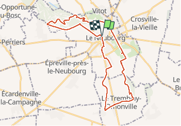
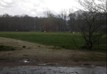
Randonnée Marche de 18,6 km à découvrir à Normandie, Eure, Le Neubourg. Cette randonnée est proposée par phiber76.

Description

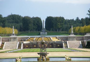
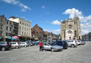
Départ du Neubourg, parking quartier Eglise.

Rando faite en sens horaire; 18,6 km

Profil altimétrique

Photos

Points d'intérêt

Point d'intérêt Le Neubourg - Pique-nique - Photo
phiber76
LE NEUBOURG 

Localisation

Pays :
France
Région :
Normandie
Département/Province :
Eure
Commune :
Le Neubourg
Localité :
Unknown
Départ:(Dec)
Départ:(UTM)
347051 ; 5446280 (31U) N.

Randonnées à proximité

Randonnée Cheval Marbeuf - rando de Noël  - Photo
Cheval
minichou

Cheval

Très facile
(1)
Marbeuf, Normandie, Eure, France
22 km | 23 km-effort
3h 28min
Oui
Randonnée Marche Sainte-Opportune-du-Bosc - Rando Vitot 10 km - Photo
Marche
GUIDE
jeanmarcMasson

Marche

Difficile
(1)
Sainte-Opportune-du-Bosc, Normandie, Eure, France
10,4 km | 12,2 km-effort
2h 45min
Oui
Randonnée Marche Le Troncq - Le Troncq (27)  - Photo
Marche
MichelRando7656

Marche

Très facile
(1)
Le Troncq, Normandie, Eure, France
13,1 km | 13,8 km-effort
2h 56min
Oui
Randonnée Marche Sainte-Opportune-du-Bosc - Circuit du champ de Bataille - Sainte-Opportune-du-Bosc - Photo
Marche
tracegps

Marche

Moyen
Sainte-Opportune-du-Bosc, Normandie, Eure, France
10,3 km | 12,1 km-effort
2h 34min
Oui
Randonnée Marche Sainte-Opportune-du-Bosc - rando Vitot - Leneubourg - Photo
Marche
GUIDE
jeanmarcMasson

Marche

Difficile
Sainte-Opportune-du-Bosc, Normandie, Eure, France
11,3 km | 13,1 km-effort
2h 19min
Oui
Randonnée Marche Sainte-Opportune-du-Bosc - sainte opportune et champ de bataille - Photo
Marche
ymarvin

Marche

Facile
Sainte-Opportune-du-Bosc, Normandie, Eure, France
6,1 km | 7,1 km-effort
1h 24min
Oui
Randonnée Vélo Le Neubourg - Boucle du Teillage -  Le Nebourg - Photo
Vélo
tracegps

Vélo

Facile
Le Neubourg, Normandie, Eure, France
16,1 km | 17,5 km-effort
45min
Oui
Randonnée Vélo Le Neubourg - Boucle de l'Oison  -  Le Neubourg - Photo
Vélo
tracegps

Vélo

Moyen
Le Neubourg, Normandie, Eure, France
31 km | 34 km-effort
1h 30min
Oui
Randonnée Vélo Le Neubourg - Boucle des Clochers  -  Le Neubourg - Photo
Vélo
tracegps

Vélo

Moyen
(1)
Le Neubourg, Normandie, Eure, France
17,4 km | 18,7 km-effort
1h 0min
Oui


Fermer
Mes abonnements